Instrument Rating - Support
Below we provide solutions, errata, omissions, exam hints & solutions. We do not provide solutions to every question - only those that students find consistently challenging.
If you have a question or concern please let us know on our contact page.
Filter by category:
1,000ft-On-Top-IFR Briefing Notes
A useful, but not often used, procedure during IFR flight is 1,000ft-On-Top-IFR. Have a read through the briefing note to see what the requirements are, and when you might use it.
1,000ft-On-Top-IFR Briefing Notes (PDF, 148 KB)
T-Routes Briefing Notes
GNSS Airways, known as T-Routes, are now the most common way to navigate in the IFR system, and are replacing airways based on conventional navaids.
T-Routes Briefing Notes (PDF, 399 KB)
Standard Terminal Arrival Procedures (STAR) Briefing Notes
STARs provide arriving aircraft with a transition from the enroute airway system to the terminal environment. They have been around for a while and have grown in importance with the integration of GPS into our air-navigation system.
Transport Canada is now testing your knowledge of STARs in the written exams. Please review the STARs Briefing Notes that are linked below. Note that these notes have been incorporated into the books beginning with the 2025 edition:
STARs Briefing Notes (PDF, 2,272 kB)
ADS-B Out Briefing Notes
ADS-B Out is now required in Class A airspace (as of Aug 10, 2023) and will be required in Class B airspace from May 16, 2024. Transport Canada is now testing your knowledge of the ADS-B system in the written exams. Please review the ADS-B Out Briefing Notes that are linked below:
ADS-B Out Briefing Notes (PDF, 120 KB)
Section 5.2.2 - VHF Omnidirectional Radio Range (VOR) Questions
Question 3 Solution (PDF, 109 KB)
Section 3.2 - Altimeter Setting Procedures and Altimeter Errors Questions
Question 13 Solution (PDF, 325 KB)
Question 14 Solution (PDF, 35 KB)
Printable Appendix Charts
For those who would like to be able to print another copy of the navigation chart, you can download the PDF file and print it out. This is handy if you've made a mistake in your calculations or markups and want to try again, or if you would prefer to use a paper chart rather than our navigation tools within the ebook appendices.
INRAT 2026 Appendix B5i (PDF, 250 KB)
INRAT 2026 Appendix C2i (PDF, 301 KB)
Navigation Log
A structured navigation log can help you plan your flights. You can use this Navlog when solving the questions within our exam preparation guides, when doing sample problems, or when going on your next cross country flight.
Navigation Log (PDF, 88 KB)
Flight Safety Foundation
The Flight Safety Foundation is a great resource for many different videos reports and analysis related to flight safety topics.
Check out their website at the link below.
Professional Pilot Magazine
Professional Pilot Magazine provides all its archived magazine issues freely available online. There is a lot of really useful content in this magazine that is definitely worth a read.
They can be found at the link below.
CAA Safety Sense Leaflets
The UK Civil Aviation Authority (CAA) has some very useful Safety Sense Leaflets covering a variety of topics, including the effect of weight and environmental conditions on takeoff and landing performance, found in their "Safety Sense: Weight, Balance and Performance" leaflet.
They can be found at the link below.
IFR Cross Country - North Bay to Elliot Lake using Ground Based Navaids
IFR flight is constantly evolving. As NavCanada continues its NavAid Modernization program, more and more ground based NavAids like VORs and NDBs are being decommissioned. The IFR Cross Country questions for the routing from North Bay to Elliot Lake has been updated for 2025 to reflect operations using GNSS equipment as the primary navigation source, and can be found in section 13.4 of the 2025 edition.
However, some of you may want to practice on questions which rely on the ground based NavAids, and the old version of this cross country flight (section 12.4 on the 2024 and earlier editions) is available in PDF format at the link below:
IFR XC: North Bay to Elliot Lake with Ground Based NavAids (PDF 1,942 kB)
VHF Line-of-sight Calculations
Calculating the maximum line-of-sight reception range for VOR or VHF radio can be tricky. Review the PDF linked below for the three most common types of questions and and explanation of how to solve each one.
VOR Reception Exam Hints (PDF, 210 KB)
Section 10.1.2 (ebook section 10.2) - Circling Approaches
The basic (standard) circling approach radii have not changed, but an additional category known as the "expanded" circling approach radii has been created.
If you see a white "C" on a black square, like the one below for the Kamloops, that means that the expanded circling approach radii apply.

The expanded circling minima are based on the aircraft category (just like the standard circling radii), but also include the circling MDA ALTITUDE. This is to account for the increased true airspeed associated with higher altitudes. Note that some categories, like category C radii, are substantially larger than what you would get if you only take into account the higher true airspeed.
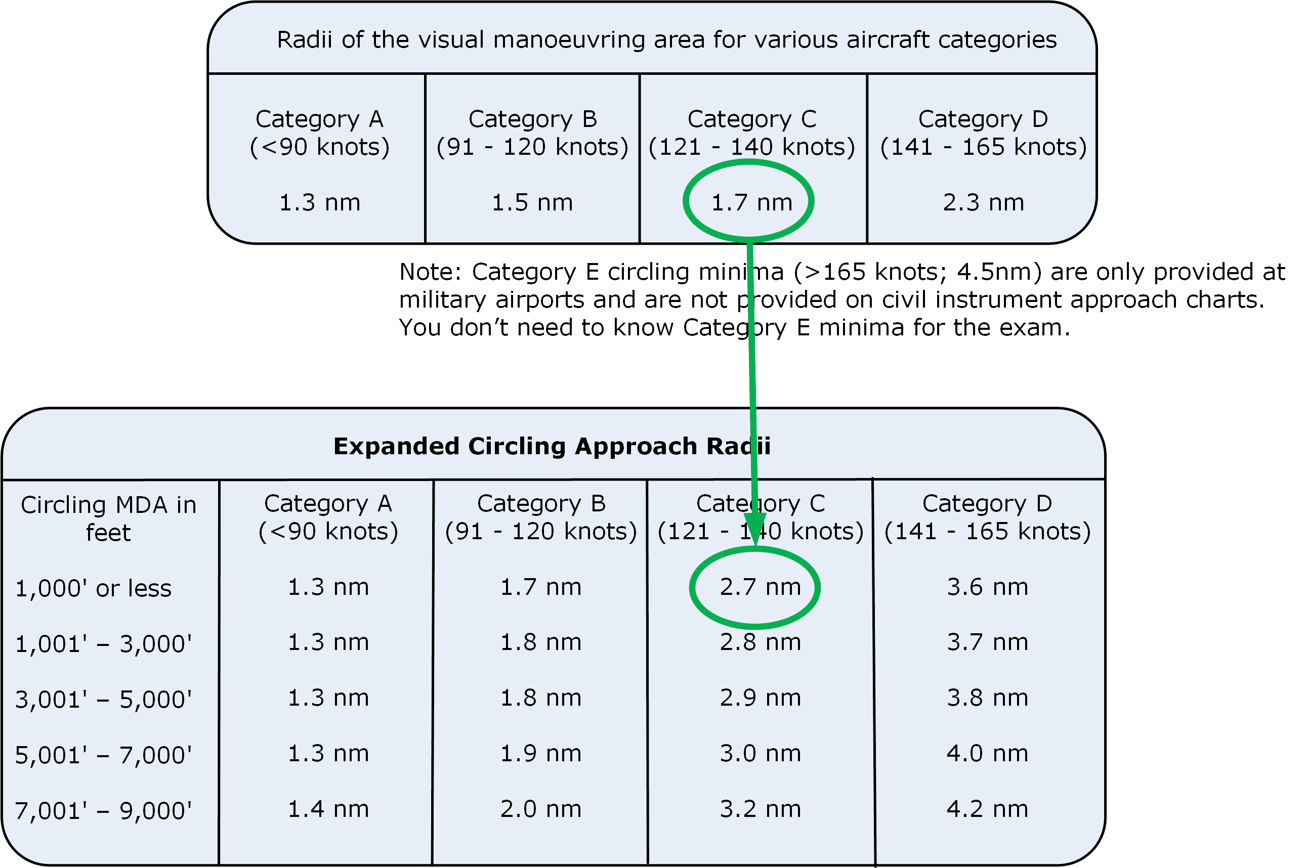
Note! To see which circling radii to use, both altitudes must be either uncorrected for temperature, or they must both be corrected for cold temperature (i.e. so you are comparing apples to apples). Remember, you're comparing the MDA altitude from the approach chart and the MDA altitude from the expanded circling approach radii.
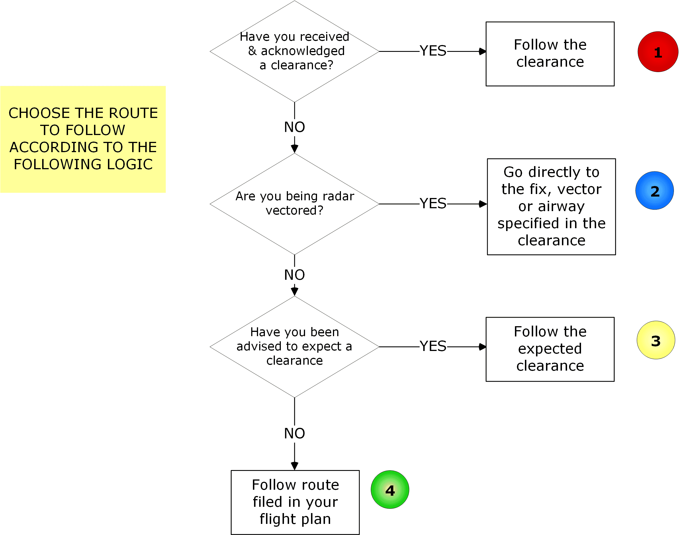
Section 12.1.1 (Section 11.1.1 in 2024 edition) - IFR Communication Failure
The flow chart indicating the priority for selecting your routing after having a communication failure while under IFR was incorrect. The correct version is shown below:
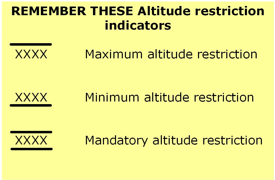
Section 9.1.9 - STARs Rules and Procedures Keynotes
The STARs altitude restrictions symbols were shown incorrectly and should appear as follows:
Section 13.4 - North Bay to Elliot Lake, Question 3
The question should read as follows:
"Calculate the enroute flight time from North Bay to Elliot Lake. You may assume a steady climb from aerodrome elevation at North Bay and a steady descent from cruising altitude to the MSA 25nm at UDLOV followed by flying the RNAV (GNSS) RWY 30 approach at Elliot Lake."
Section 10.3.2 - Alternate Minima, Question 8 (ebook C16-006)
Answer c) should say "537 - 3".
Section 14 - INRAT Sample Exam, Question 38 (ebook C25-038)
To solve this question correctly, you need to know that you are flying in a piston single engine aircraft.