Private Pilot - Support
Below we provide solutions, errata, omissions, exam hints & solutions. Please use the filter buttons to find the information relavent to your exam preparation guide year.
We do not provide solutions to every question - only those that students find consistently challenging.
If you have a question please let us know on our contact page.
Filter by category:
T-Routes Briefing Notes
GNSS Airways, known as T-Routes, are now the most common way to navigate in the IFR system, and are replacing airways based on conventional navaids.
T-Routes Briefing Notes (PDF, 399 KB)
ADS-B Out Briefing Notes
ADS-B Out is now required in Class A airspace (as of Aug 10, 2023) and will be required in Class B airspace from May 16, 2024. Transport Canada is now testing your knowledge of the ADS-B system in the written exams. Please review the ADS-B Out Briefing Notes that are linked below:
ADS-B Out Briefing Notes (PDF, 120 KB)
Section 4.2 - General Knowledge Questions - Calculating True Airspeed
Question 9 of this section asks you to calculate your true airspeed given some input information. This is useful to verify your performance in flight matches what you calculated ahead of time.
Question 9 Solution (PDF, 494 KB)
NDB, VOR and DME Keynotes
The NDB, VOR and DME systems are no longer examined on the Private Pilot examinations and so these subjects have been removed from the Sharper Edge Exam preparation guides starting with the 2027 year. If you're interested to learn about them, the keynotes for those systems are saved at the link below.
NDB, VOR and DME keynotes (PDF, 568 KB)
Printable Appendix Charts
For those who would like to be able to print another copy of the navigation chart, you can download the PDF file and print it out. This is handy if you've made a mistake in your calculations or markups and want to try again, or if you would prefer to use a paper chart rather than our navigation tools within the ebook appendices.
PPL 2026 Appendix C (PDF, 5,490 KB)
Navigation Log
A structured navigation log can help you plan your flights. You can use this Navlog when solving the questions within our exam preparation guides, when doing sample problems, or when going on your next cross country flight.
Navigation Log (PDF, 88 KB)
Flight Safety Foundation
The Flight Safety Foundation is a great resource for many different videos reports and analysis related to flight safety topics.
Check out their website at the link below.
CAA Safety Sense Leaflets
The UK Civil Aviation Authority (CAA) has some very useful Safety Sense Leaflets covering a variety of topics, including the effect of weight and environmental conditions on takeoff and landing performance, found in their "Safety Sense: Weight, Balance and Performance" leaflet.
They can be found at the link below.
VHF Line-of-sight Calculations
Calculating the maximum line-of-sight reception range for VOR or VHF radio can be tricky. Review the PDF linked below for the three most common types of questions and and explanation of how to solve each one.
VOR Reception Exam Hints (PDF, 210 KB)
Section 1 - Air Law - Question 88:
The correct answer should be:
b) The aeroplane shall give way to the glider
Section 2 - Meteorology - Question 42:
The answers to this question were not clear, and are revised as follows. The correct answer remains unchanged as answer "c".
a) No cloud below 3,000', no precipitation, no Cb's, no thunderstorm activity, no fog or drifting snow and a visibility of 15 miles or more
b) No cloud below 5,000', no precipitation, no Cb's, no thunderstorm activity, no fog or drifting snow and a visibility of 5 miles or more
c) No cloud below 5,000', no precipitation, no Cb's, no thunderstorm activity, no fog or drifting snow and a visibility of 6 miles or more
d) None of the above
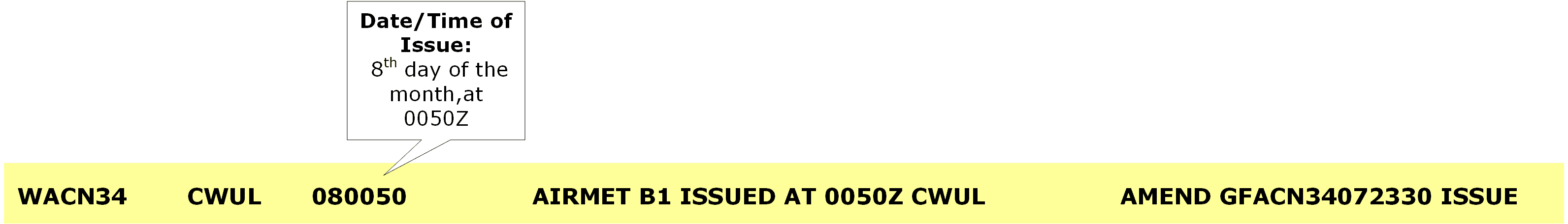
AIRMET Interpretation, Section 2.14.:
A typographical error was present in the date code interpretation of the AIRMET. The correct date code interpretation is presented below:
Section 3 - Navigation - Question 92 - True Altitude Calculations
The correct answer to Navigation Question 92 should be:
b) 1,250'
Rhumb Lines and Great Circle Lines on Transverse Mercator Projections:
The following changes are made to the description of Rhumb and Great Circle lines on the Transverse Mercator projection, which is used on the VTA charts.
Rhumb Lines: Arc - bulged towards the nearest pole
Great Circle Lines: Approximates a straight line
These details are updated on: Navigation section 3.1.1.2 “Chart Properties”, page 125, which is reproduced below:
Chart Properties (PDF, 86 KB)
Wake Turbulence Separation
Transport Canada has updated the wake turbulence categories in AIM RAC 4.1.1 to show in kilograms (kg), not in pounds (lb). Make sure you know the categories in kilograms for the exams.
The Super Heavy wake turbulence category was added, and separation distances between Super Heavy and other categories are updated.
Refer to AIM RAC 4.1.1, Table 4.1 - Separation per Aircraft Category for Wake Turbulence Purposes
WAC Charts No Longer Available:
Both Canada and the United States of America have stopped production of the 1:1,000,000 scale World Aeronautical Charts (WAC). You no longer need to know the details of WAC charts for your TC exams!
The details of WAC charts have been removed from: Navigation section 3.1.1.2 “Chart Properties”, page 125